Highway 323 runs north-west from Kanchanaburi for roughly 220km to Sangkhlaburi, close to the Myanmar border. For the first eighty kilometres it shadows the route of the Thailand-Burma railway built by Allied prisoners of war and Asian labourers between 1942 and 1943, passing the war cemeteries, the bridge, the wooden viaduct and the cutting at Hellfire Pass. After Thong Pha Phum it stops being a memorial road and becomes one of the better mountain drives in central Thailand.
Most visitors see the first thirty kilometres of it on a day trip from Bangkok and turn round. The road past Hellfire Pass is where it gets interesting, and hardly anyone goes.
- Kanchanaburi to SangkhlaburiAbout 220km on Highway 323
- Driving time4-5 hours without stops
- Hellfire PassAbout 80km from Kanchanaburi
- Time needed3 days minimum to do it properly
- Best seasonNovember to February
Getting to Kanchanaburi
Kanchanaburi is about 130km west of Bangkok. The traditional route is Highway 4 (Phetkasem) to Nakhon Pathom and then Highway 323 north-west, which takes two to three hours depending on how badly Bangkok is behaving when you leave. A motorway between the western edge of Bangkok and Kanchanaburi has been opening in stages and shortens the run considerably where it is in service; check what is actually running before you plan around it, and see Thailand's expressways and motorways for how the two toll networks differ.
The town itself sits on the Khwae Yai river and is compact, flat and easy to drive. The riverside guesthouse strip, the two war cemeteries, the Thailand-Burma Railway Centre and the bridge are all within a few kilometres of each other.
The road north, stage by stage
| From Kanchanaburi | Place | What is there |
|---|---|---|
| 0km | Kanchanaburi | Bridge, cemeteries, railway museum |
| about 65km (via Route 3199) | Erawan Falls | Seven-tier waterfall, national park |
| about 55km | Tham Krasae | Wooden viaduct on the surviving railway |
| about 80km | Hellfire Pass | Memorial museum and the cutting |
| about 100km | Sai Yok Yai | Waterfall falling directly into the river |
| about 140km | Thong Pha Phum | Last proper town; dam and reservoir |
| about 220km | Sangkhlaburi | Mon Bridge, sunken temple, Mon community |
Hellfire Pass is the site everyone comes for. It is a cutting through solid rock, hacked out largely by hand and largely at night by lamplight, which is where the name comes from. The Australian-funded memorial museum at the top is excellent and free to enter, with an audio guide; the walk down into the cutting and along the old formation takes an hour or more and is steep coming back up. It sits directly on Highway 323 with a signed car park.
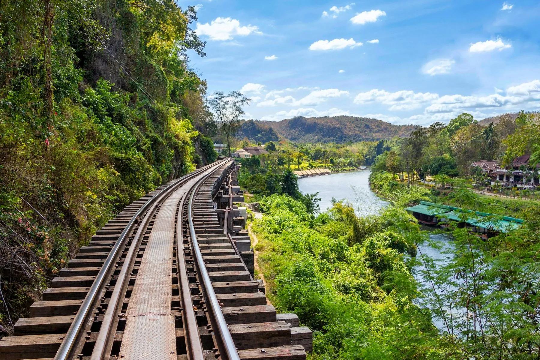
Tham Krasae is the wooden trestle viaduct where the surviving section of railway is pinned to a cliff above the river. Trains still run over it several times a day on the Bangkok to Nam Tok line, and you can walk the track.
Erawan Falls is not on Highway 323 — it is up Route 3199, a signed turn north-east of Kanchanaburi, about 65km from town. It is a seven-tier limestone cascade with turquoise pools, inside a national park with an entrance fee, and the climb to the upper levels is a proper walk. It is also extremely busy at weekends.
Where the road gets good: Thong Pha Phum to Sangkhlaburi
Thong Pha Phum is the last town of any size, about 140km up. Beyond it the Vajiralongkorn dam has flooded a long valley, and Highway 323 climbs away from the water and runs along the hillsides for the remaining seventy kilometres to Sangkhlaburi.
This section is a genuine mountain road: continuous bends, real gradient, forest on both sides, and long views down over the reservoir. The surface is good and the traffic is light. It takes about an hour and a half and it is the reason to drive the full length of the 323 rather than stopping at Hellfire Pass.
The last seventy kilometres have almost no services and patchy phone coverage. Fill up in Thong Pha Phum, whichever direction you are going. There are long stretches with no houses, no fuel and nowhere to turn to for help, and the road is high enough and remote enough that a breakdown is a genuine inconvenience. See what to do when you break down in Thailand.
Sangkhlaburi is the end of the road and worth the drive. It sits at the head of the reservoir and is largely a Mon town, with a population descended from refugees who crossed from Burma over several decades. The Mon Bridge — Saphan Mon — is a wooden footbridge several hundred metres long across an arm of the lake, the longest of its kind in Thailand, and it is the centre of the place. When the water is low, the tops of a submerged temple emerge from the reservoir and can be reached by longtail boat.
Three Pagodas Pass is about 20km beyond Sangkhlaburi at the Myanmar border, and is the point at which the railway crossed into Burma. The pagodas themselves are small and the site is modest. Whether the crossing itself is open to foreign visitors has varied considerably over the years and should be checked against current advice before you drive out; assume it is not.
What the road demands
The first 140km, as far as Thong Pha Phum, is easy: a wide two-lane highway across gently rolling country, with plenty of overtaking room. The last 70km is a different road — narrower, steeper, and with a sequence of blind bends where you will meet the occasional lorry or bus using the middle of the carriageway.
Specific things to watch:
- The descent into Sangkhlaburi is long. On a small motorbike, brake fade is a real possibility; use the engine.
- Fog and low cloud sit on the higher sections in the early morning during the cool season, and visibility can drop sharply.
- Wildlife. Highway 323 passes through and beside several national parks and wildlife sanctuaries. Deer and elephants have been recorded on this corridor, and neither will move for you.
- Roadworks and landslip repairs are common on the upper section after the rains, sometimes with single-lane working and no advance warning. See roadworks and unmarked hazards.
Stay in Sangkhlaburi, not Thong Pha Phum
The temptation is to drive up, look at the Mon Bridge and drive back the same day — that is nine or ten hours in a vehicle. Sangkhlaburi at dawn, with mist on the lake and the bridge full of monks and schoolchildren, is completely different from Sangkhlaburi at two in the afternoon. Stay the night.
Which vehicle
A car is the easy answer, and Kanchanaburi is close enough to Bangkok that driving out in a hire car makes sense. The full road is sealed throughout and needs nothing special.
On a motorbike this is one of the better rides in central Thailand, and Kanchanaburi has a reasonable rental scene aimed at travellers — see renting a motorbike in Kanchanaburi. A 125cc scooter is fine for the day-trip radius: the bridge, the cemeteries, Erawan and Hellfire Pass. For the run to Sangkhlaburi, take something bigger. It is 220km each way with a mountain section at the far end, and small rental shops frequently limit how far you may take the bike anyway.
When to go
November to February is the best window: dry, comfortable, with cool mornings in the hills. This is also when the waterfalls still have water from the wet season and the reservoir is high.
March to May is very hot in Kanchanaburi province, which sits in a river basin and traps it. The falls shrink. Hellfire Pass in full afternoon sun is genuinely unpleasant, and the walk down into the cutting is exposed.
June to October brings heavy rain to these hills. The waterfalls are at their most spectacular and the mountain section becomes slippery, with debris and occasional slips on the upper road. The reservoir is high, which means the sunken temple at Sangkhlaburi is fully submerged.
Erawan and the Kanchanaburi sights are busy at Thai weekends and public holidays. Midweek the difference is dramatic.
The Death Railway line still operates from Bangkok to Nam Tok, running over the bridge and across the Tham Krasae viaduct. Driving to Nam Tok and taking the short train section as a return trip is a common and sensible way to do both.
Frequently asked questions
How far is Hellfire Pass from Kanchanaburi?
About 80km up Highway 323, roughly an hour and a quarter by car. It is signed from the road and has its own car park. The memorial museum is free and the walk into the cutting takes an hour or more.
Can I do Kanchanaburi as a day trip from Bangkok?
You can reach the town, the bridge and the cemeteries in a day, and many people do. Adding Hellfire Pass makes it a long day. Adding Erawan as well makes it an unreasonable one. Two nights in Kanchanaburi is the sensible minimum.
Is the road to Sangkhlaburi difficult?
The first 140km is easy. The final 70km from Thong Pha Phum is a proper mountain road with continuous bends, real gradient and very few services. It is well surfaced and not technically hard, but it demands attention and a vehicle with decent brakes.
Can I cross into Myanmar at Three Pagodas Pass?
Do not plan on it. Access for foreign visitors at this crossing has opened and closed repeatedly over the years, and taking a Thai rental vehicle across any land border is prohibited by essentially every rental agreement. Check current official travel advice before driving out there at all.
Is a scooter enough?
For Kanchanaburi town, Erawan and Hellfire Pass, yes. For the full run to Sangkhlaburi, take a larger machine or a car — 440km round trip with a mountain section is beyond what a 125cc rental is meant for, and your rental agreement may not permit it.
What is the best single stop on the road?
Hellfire Pass, without question, for what it is. For driving, the Thong Pha Phum to Sangkhlaburi section. For a swim, Erawan.
Kanchanaburi works well as the first leg of a longer western trip, or as a two-night break from Bangkok. If you are planning a first Thai road trip, see the one-week driving itinerary; if you are heading south instead, Bangkok to Hua Hin covers the other obvious weekend drive out of the capital.